Austin Headlines: Urban Rail Plan Taking Shape (again)

Source: City of Austin.

Source: City of Austin.

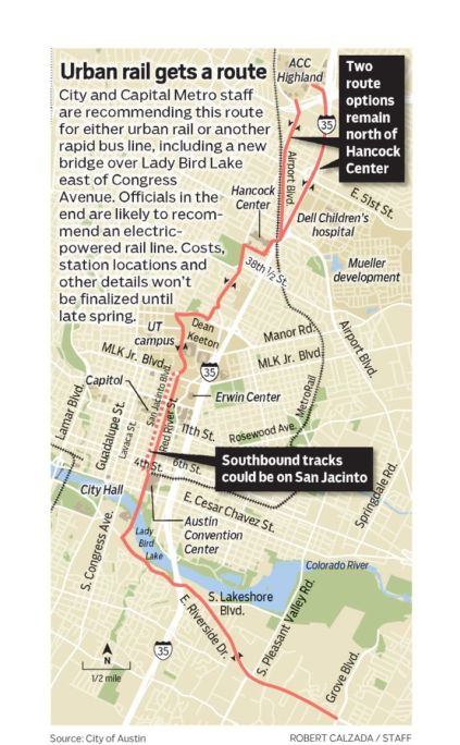
Austin’s urban rail unveiled: Highland Mall to East Riverside DriveAustin American-Statesman

Ben Wear – Officials proposed a nine-mile route that would run from the emerging Austin Community College campus at Highland Mall through the University of Texas, downtown and along East Riverside Drive to Grove Boulevard. The proposal is expected to take final form this summer, where the Austin City Council will decide by August whether to put a bond proposal on the November ballot.

At the moment, there are a host of unknowns: the cost of construction; annual operating costs and what entity or entities would cover those costs; who will run the line; where the train would have its own dedicated corridor; and where stations would be located. A huge question mark is how and when the line will cross Lady Bird Lake. The final recommendation that will be put to the City Council, along with details about stations, train technology, financing and governance of the line, is expected emerge by April.

South Austin’s beleaguered Violet Crown Trail moves ahead despite setbacks – Community Impact

The proposed Violet Crown Trail is a 30-mile network of trails from Zilker Park to south of FM 967 in Hays County. So far, the trail’s first phase — 5 miles of walkways in Zilker Park — has been built. Attention is now focusing on the second phase of the trail, a 7-mile segment that will link Sunset Valley to the Veloway, a popular closed cycling and skating loop, and the Lady Bird Johnson Wildflower Center. Construction is expected to get underway by early summer. For more information, see here.

Austin City Council Votes to Lower Occupancy Limits – KUT News

Council took the issue of so-called  “stealth dorms” to task, passing a resolution to lower the number of unrelated adults allowed to live in a single-family home from six to four. Some argue these living arrangements provide affordability for Austinites because of the rising price of Austin real estate, while others say they lead to parking and trash problems that disrupt neighborhoods and lower property values.

‘Streets’

  • Bicycle Bridge Project Begins on Mopac in South Austin – TxDOT
  • Permanent food trailer court to open at 1-acre Barton Springs Road site – The Daily Texan

Bicycling

  • Twice as many people as anticipated have used Austin B-cycle in it’s first two months – Austin Post

Transit

  • Is Capital Metro’s new MetroRapid service leaving bus riders behind? KUT News
  • Capital Metro plans to remove nearly all buses from Congress Avenue – Austin Business Journal
  • Rail or fail: Austin mayor touts urban rail in final State of the City address – Community Impact

Roads/Parking

  • Heading for the hills? West Lake has a vintage bottleneck – Austin American-Statesman
  • Transportation planners could add lanes to Highway 183 in Northwest Austin – KVUE
  • TxDOT proposes closing Woodland access to I-35 to ease congestion – Austin Post

Development projects

Green spaces/Leisure

Around Texas

  • Judge Strikes Down New Braunfels’ River ‘Can Ban’ – KUT News
  • With three new companies, Temple sees fruits of energy boom – Austin Business Journal
  • At DFW, a DART Orange Line connection to downtown Dallas mere months away – Dallas News Transportation Blog
  • TxDOT to Dallas: Elevated highway separating Deep Ellum from downtown will remain for the foreseeable future – Planetizen
  • Turning Urban Blight into Urban Amenity: Houston’s Buffalo Bayou Promenade – Metropolis

Regional Matters

Urban Rail in Austin: City’s Expanded Plan

With a possible vote on the first segment looming in November, the City of Austin has added 10 miles of track to the 16.5-mile, $1.3 billion urban rail system proposal that has long been public. The newest map released by Capital Metro imagines rail lines extending south, west and north of the urban core and Central Business District:

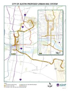
North of the Colorado River, the map shows two westward extensions to MoPac (at 5th St. and 35th. St.), and a extension to the Crestview MetroRail Station in North Central Austin. In South Austin, rail will run down Congress Avenue to Southpark Meadows. Additionally, a line would run east-west on West Riverside Drive past Auditorium Shores. Previous versions have been criticized for being too downtown-centric and for bypassing the vital north-south Lamar/Guadalupe corridor. Here’s what the old map (from 2009):

Proposed Urban Rail System. 2009.

Proposed Urban Rail System. 2009.

According to the new map, the city intends for rail to cross Lake Lady Bird on a new bridge near Waller Creek. Whereas the plan previously considered using the existing Congress Avenue, Austin Transportation’s Department now envisions a “statement bridge” reserved for trains, buses, bikes and pedestrians.

There are several problems with this proposed route that are beyond the scope of the post (e.g., Lamar Boulevard), and the Austin City Council has yet to release a price estimate. That should happen within the month, at which point the proposed routes will need to be examined more closely.

For Austin, Wheels in Motion for Bus Rapid Transit by 2014

It’s been a little over two years since MetroRail debuted as Austin’s urban rail. Following a trend that started in Latin America and has spread throughout the world, Austin says it is preparing to break ground on a high-capacity rapid bus. That’s right, ladies and gentlemen, Bus Rapid Transit (BRT) is coming to Austin.

Thanks in large part to Department of Transportation grant that will fund 80% of the project, construction of a two-route, $47.6 million rapid-bus system known as MetroRapid will begin this fall. The FTA’s Very Small Starts program will cover some 80 percent $47.6 million total cost.

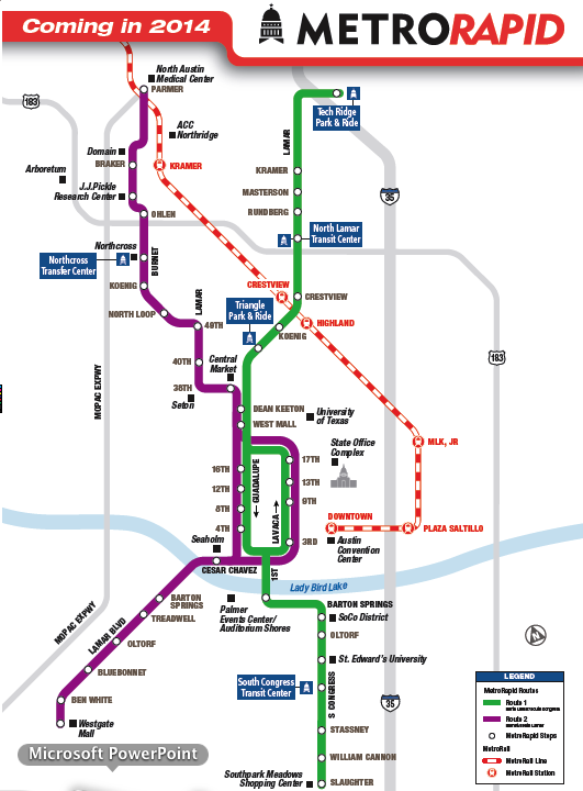
Capital Metro says MetroRapid can anticipate at least 20,000 daily boardings after the service opens. Plans include two high-capacity, rapid bus lines that would run north-south across the city for a total of 37.5 miles. The North Lamar Boulevard/South Congress Avenue line will run for a total of 21 miles from Tech Ridge Park and Ride to Southpark Meadows. The Burnet/South Lamar Boulevard will total 16 miles and will run from North Austin Medical Center to Westgate Transit Center.


Like other BRT systems, MetroRapid will feature sleek, modern buses that are more efficient and have greater passenger amenities on the bus and at the station that a standard bus. MetroRapid’s fleet will consists of 60 accordion-style buses is expected to run at intervals of 10-15 minutes from 5am to 1am – much shorter than anything Austinites are used to.

The buses would arrive by 2014, and the lines would open after completion of 70 stations that would be located every mile or so, on both sides of the street. Each of these “Enhanced Bus Stops” with a bench, system map, standard route sign and a real-time digital display of anticipated arrival times.

Austins’s far from the only city in North America looking to BRT. In Texas alone, both San Antonio and El Paso
expect to open their own BRT systems within the next 1-3 years.

11 Urban Railways in Brazil

South America’s largest country is home to a new crop of projects designed to promote urban mobility in advance of the World Cup in 2014. Indeed, Brazil’s cities have are home to a new generation of subway, commuter rail, light rail and monorail projects.

1. São Paulo – Known simply as the “Metro” to commuters, the Metropolitano São Paulo consists of five lines, 63 stations and carries 3,600,000 passengers a day. The system, opened in 1974, is modern and the largest in South America in terms of ridership, it’s 61km is not considered sufficient for a city of over 16 million. New lines and stations have been built in advance of the World Cup in 2014. Additionally, the Metro connects to a commuter rail known as the the CPTM (Companhi Paulista de Trens Metropolitanos (CPTM) that serves the greater São Paulo area that was completed in 1992. Together, the two systems carry 5.2 million people each day.

2. Rio de Janeiro – Founded in 1979, Metrô Rio is a partially underground railway that carries 580,000 commuters each day – or 5% of commuters. The second-largest rail network in Brazil, it covers 47km and is divided into two lines and 25 stations. A condition of being awarded the Olympics, the metro is currently undergoing a massive expansion that aims to increase ridership to 1,100,000 a day by 2016. Additionally, the 8-line commuter rail called SuperVia. which carries an additional 510,000 passengers each day, is being upgraded as well.

3. Belo Horizonte – The Metrô de Belo Horizonte consists of one above-ground line that carries 145,000 passengers. Construction began on its first of 19 stations in 1981 and commercial service in 1986. However, the vast majority of BH’s 5.5 million inhabitants, rely on buses and taxis.

4. Brasília – Commissioned in 2001, the Metrô de Brasília is the two-line and 29-station urban rail system that carries 150,000 passengers daily. Construction began in 2009 on a Light Rail Transit (LRT) extension connecting downtown to the airport in hopes it will be completed by 2014.

5. Porto Alegre – The Metrô de Porto Alegre began operation in 1985. It began as a commuter rail built to serve Porto Alegre’s northern suburbs, and still only consists of one line and 17 stations. Commonly called the “trem,” the system carries some 130,000 commuters daily and covers 33.5km of track.

6. Recife – The Metrô do Recife is a rapid transit system consisting of two lines, 29 stations and serving 210,000 people each day. Recife’s metro began operation in 1985, and will be the second largest metro in Brazil after São Paulo.

7. Teresina – The single-line Metrô de Teresina is the smallest urban rail system in Brazil and has been in operation since 1990. The 9 stations and 13.5 miles of track carry up to 20,000 people on an average day.

8. Cariri – Adjacent to Fortaleza in northeast Brazil, the Metrô do Cariri is an above-ground light rail system that carries 1,000 daily. The single-line system consists of 9 stations and 13.6km of track, and was completed in 2010.

9. Maceió (under construction)The Metropolitano de Maceió is a single-line light rail system that will connect Maceió to its northern suburbs.

10. Fortaleza (under construction) – Currently under construction, the Metrô de Fortaleza is rapid transit system and is expected to be completed in mid-2012. The two-line light rail system will consist of 43 miles of track between the cities of Fortaleza, Caucaia, Marazion and Pacatuba. When all stages are completed after 2014, the “Metrofor” is expected to transport up to 700,000 each day.

11. Salvador (under construction) – Projected to begin operation in 2012, the Metrô de Salvador consists of two lines and 19 stations.